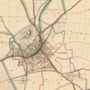
Historic map of Cashel
Historic Mapping Products
Our first edition 6 Inch mapping was surveyed between 1829 and 1834 and printed between 1829 and 1941. These are available in both black & white and colour editions with national coverage available.
The 25 Inch mapping series was surveyed between 1863 and 1924. These black and white maps allowed for greater detail than the previous 6 Inch series.
A later revision of the 6 Inch series (6 Inch Last edition) was completed between the 1830’s and the 1930’s and is available in black and white.
These Historic Datasets are available as Historic Maps and Historic data extracts.
- 6 Inch Colour (1829-41) A4 PDF
- 6 Inch B&W (1829-41) A4 PDF
- 25 Inch B&W (1897-1913) A4 PDF
- 6 Inch Colour (1829-41) A0 or Full Sheet Print
- 6 Inch B&W (1829-41) A0 or Full Sheet Print
- 25 Inch B&W (1897-1913) A0 or Full Sheet Print
Historic Maps
A site-centred paper plot of your area of interest produced using your selected historic mapping series with the supporting marginalia of a traditional cartographic map. Extracts are available in either Landscape or Portrait orientation. Our A4 and A3-size Historic maps are output as print-optimised PDF digital documents and are available to download for immediate printing. A2/A1/A0 size maps are professionally printed in-house, or through one of our agents, and shipped by post.
For further information please contact mapsales@tailte.ie.
Purchase a Historic Map on the online store
Historic Extracts
We provides digitally scanned georeferenced options for our various Historic Mapping series in raster data tiff format. These Historic Extracts are of interest to professional users who wish to import our data into their own CAD/GIS environments for a range of additional uses in support of their own project workflows. They are available as set tiles for national and specific area of interests supplies and all imagery is compatible with all our other digital data products in ITM projection.
For further information please contact mapsales@tailte.ie.
Purchase a Historic Extract on the online store

