A new National Landcover Map for Ireland
Tailte Éireann and the Environmental Protection Agency launched the most extensive and detailed landcover map ever created for the Republic of Ireland in 2023.
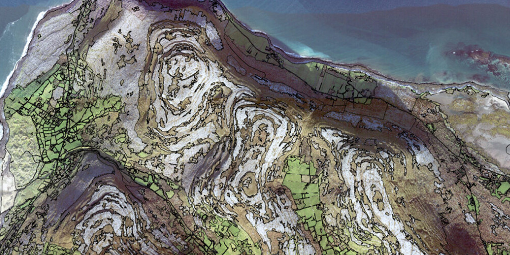
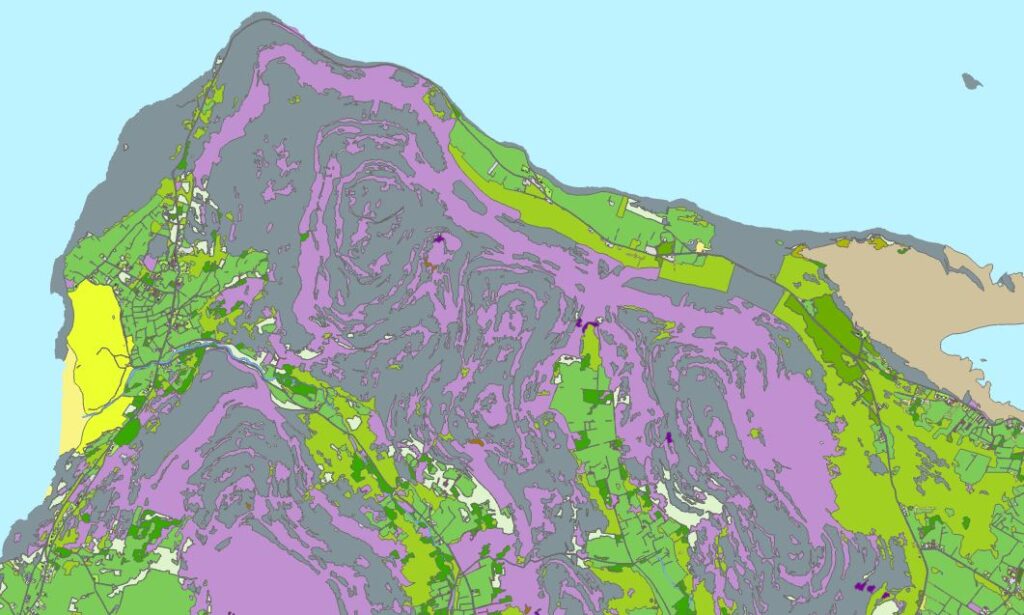
Landcover is the term used to refer to whatever is physically present on the Earth’s surface, whether this is natural vegetation, freshwater or non-living surfaces. The landcover of the Republic of Ireland is incredibly diverse, including forestry, peat bogs, grassland, sand dunes, mud flats, salt marsh, bracken, hedgerows and more, as well as man-made structures and cultivated fields. Now, for the first time, all of these different types of landcover have been categorised and mapped in detail, in a project delivered by Tailte Éireann - Surveying in partnership with the Environmental Protection Agency (EPA).
Together, Tailte Éireann and EPA have created a brand new resource called the National Landcover Map for the Republic of Ireland that covers the whole of the country and is significantly more detailed than any other national landcover dataset previously produced. It offers significant benefits for all kinds of government, commercial and environmental organisations and is a great example of what can be achieved through effective public sector collaboration.

Providing 250 times more detail
Prior to the development of the new National Landcover Map, landcover in Ireland was assessed using CORINE, a pan-European landcover dataset, produced by the European Economic Area (EEA). In Ireland, the EPA generates CORINE data for the EEA under the Copernicus Land Monitoring Service, and the dataset provides an important time series of data for 1990, 2000, 2006, 2012 and 2018. However, although CORINE is valuable, it has long been recognised that CORINE lacks the detail needed to carry out national assessments across various sectors.
There has, therefore, for many years, been a long-term initiative to supplement CORINE with improved data on landcover, land-use and habitat mapping in Ireland, driven by members of the cross-governmental national landcover and habitat mapping (NLCHM) working group. The National Landcover Map is a product of this collaboration. It has a resolution of at least 0.1 hectares, whereas CORINE is only mapped at 25-hectare resolution. Consequently, the new National Landcover Map is 250 times more detailed and capable of showing much smaller features.
Harnessing machine learning
The National Landcover Map was produced by Tailte Éireann and EPA using an innovative mapping methodology that was designed to enable the two organisations to classify over 10 million landcover features in the landscape. The semi-automated approach uses remote sensing on aerial and satellite images, integrates existing national data and takes advantage of rule-based and machine learning classification approaches to predict the most likely landcover class.
Tailte Éireann worked closely with BEC Consultants Ltd, an ecology consultancy based in Dublin, throughout this process to ensure that the artificial intelligence (AI) technology was identifying land cover types correctly. It then involved seven external stakeholders, giving them access to the data so that they could validate the emerging picture of Ireland’s landscape using their local and specialist knowledge of landcover. This comprehensive and independent validation programme, carried out in collaboration with the Central Statistics Office (CSO), involved the validation of over 20,000 landcover samples. It is the first validation project of its kind ever undertaken in Ireland and gives users confidence in the quality of the data in the National Landcover Map.
Revealing unique land characteristics
The National Landcover Map includes 36 different land classifications, many of which are unique to Ireland. During the development of the map, Tailte Éireann and EPA realised that many of the land classifications commonly used elsewhere in Europe were not applicable to Ireland, while several different classifications were needed to properly describe typical environments in Ireland. The two organisations therefore worked with other stakeholders to define a set of land classifications specifically for Ireland, to provide the best and most precise descriptions of land types commonly found across the country.
Reflecting the diversity and distinctiveness of Ireland’s rural and coastal areas, the classifications describe the actual landscape of Ireland and range from dry heath, fens and swamp to buildings and artificial waterbodies. Grassland is not one classification, but four: amenity grassland, wet grassland, dry grassland and improved grassland. Similarly, forests are sub-divided into mixed forest, broadleaved forest and woodland, transitional forest, coniferous forest and treelines. Other key classifications include blanket bog, raised bog, cutover bog, fens and bare peat. With this level of detail and data that is specific to Irish landscapes, the National Landcover Map will fundamentally change our understanding of land status in Ireland.
Delivering public sector cost efficiencies
The launch of the National Landcover Map will create significant efficiencies across the Irish public sector. All government departments can use this single source of landcover data to inform their work and focus their efforts on analysing and using the information, rather than collecting it. They can access the National Landcover Map through the National Mapping Agreement, at no additional cost.
In the past, several government agencies collected and maintained landcover data for their own use, duplicating the effort of other public sector bodies. These mini maps with partial data, mostly covering just small areas of the country, can now be replaced by this detailed and standardised map for the whole of the Republic of Ireland, maintained by Tailte Éireann - Surveying. While it is likely that the National Landcover Map will be primarily used by public sector organisations, it will also be made available to commercial businesses through Tailte Éireann data services.
Showing landscape changes over time
The National Landcover Map has been developed using remote sensing data from 2018, and updated versions of the map will be released over time based on new ortho-photography collected in the coming years. With the release of each new iteration of the National Landcover Map, users will be able to make comparisons and observe changes in the landscape. This will be of huge benefit for organisations involved in environmental improvement projects, as they will be able to monitor the success of initiatives to improve or expand specific habitats or land types. The National Landcover Map could inform future rewetting schemes and help organisations accurately calculate the amount of carbon that is sequestered from the atmosphere by peat bogs throughout the country.
Without doubt, the publication of the National Landcover Map is a change for the better. Until now, public sector organisations, environmental consultancies and commercial businesses alike have all had to either rely on CORINE data or spend time and money collecting their own data. With the launch of the National Landcover Map, however, all public and private sector organisations now have easy access to comprehensive, detailed landcover data for the whole of Ireland, that is ready to use. In the months and years ahead, this valuable new resource has the potential to transform our understanding of important habitats, deepen our knowledge of climate risks and inform our actions to improve the environment around us.